Showing posts with label White Mountains. Show all posts

Friday, August 17, 2012

Day 8 - Camden, ME to Gorham, NH and 51 Bottles of Beer

We spent much of dinner discussing the next destination, and future life plans.  There is something about a trip like this that makes you dissect your life and wonder if you are on track.  Setting aside life goals, we had to figure out our short-term objectives.

We both really, really wanted to visit Nova Scotia, Newfoundland, Prince Edward Island, or all of the above.  Before we left on this trip I had developed multiple routes and options.  It all comes down to the pace of the trip.  We could easily get into Nova Scotia and beyond.  Unfortunately we would have been in for many more long or marathon long days.  Was that what we really wanted?

In the back of Oilburner's mind he kept circling on Mount Washington and the Auto Road.  (OK, this was on my mind as well.)  As much as we wanted to traipse across Eastern Canada, we weren't interested in continuing the long, hard days.  We were more interested in a relaxing journey towards home.  And the weather was cooperating with that idea since predictions for the White Mountains, and Mount Washington, were completely clear.  Destiny decided our route was back towards New Hampshire.

Friday dawns and we are prepared to leave Maine behind.  Sigh.  We had meant to visit Mount Battie right outside of Camden.  Mount Battie is a knob jutting from the South end of the Camden Hills, but its proximity to Camden and sheer rock faces are what sets this aside.  At 800 feet elevation it affords great views of the surrounding area and harbor.  Unfortunately...we forgot our intent and missed it.  Someone didn't want to turn around and go back.  :)
Image Taken from Maine.gov website
The destination was Gorham, New Hampshire, a mere 8 miles from the Auto Road.  We took our time, with advice from some locals took a few back roads, and all was well.  As has been said by Circle Blue it's a good day when you can say "We rode, we ate, nothing happened, and we arrived safe."

We reached Gorham without lodging plans, and just stopped at the big, white lodge on the side of the road that had quite a few bikes parked in front of it.  We snagged the last queen bed room (otherwise it was a two twin bed setup) and set about off-loading the bikes.

Now...when do we make our attack on Mount Washington?  Tonight or tomorrow?  We talked, studied weather reports, analyzed weather patterns and decided to go today.  The humidity and wind seemed a little lower.

Off.    We.    Go.

Temperatures at the beginning of the Auto Road:  87F
Temperatures at the end, the summit: 54F
Length of the road:  7.6 miles
% paved: 87
% gravel: 13
Warning Sign before setting tire on road:

ATTENTION
THE MT. WASHINGTON AUTO ROAD
IS A STEEP, NARROW, MOUNTAIN ROAD
WITHOUT GUARDRAILS. IF YOU HAVE A
FEAR OF HEIGHTS, YOU MAY NOT
APPRECIATE THIS DRIVING EXPERIENCE.
GUIDED TOURS ARE AVAILABLE.

Upper portion of the Auto Road as seen from Google Earth
 We paid our toll: $15.00 per bike.  Received our stickers "This bike climbed Mount Washington" and were on our way.


The first couple miles are great: beautiful trees, horrible drivers that just can't stick to the 20 mph, frost heaves and chewed up tracks from the winter snow coach.  (I haven't said anything about the new Heidenaus...but they follow every damn groove in the road.  The rough paths of the snow coach were particularly hair raising.)  I found that I couldn't do any "sightseeing" due to target fixation.  No guardrails, sheer drops and 12-22% grade do not lend to admiring that view off in the distance.
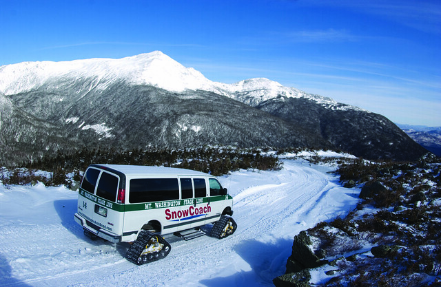
Snow Coach descending on a clear day
I really want to do this!  Snowcoach image taken from http://mtwashingtonautoroad.com/guided-tours/snowcoach/
I'm cool with it though. I'm cool. I'm cool....until that damn dirt, and the hair pin turn at mile 6 that is completely engineered WRONG. (Yeah...take the bad grammar as a hint as to how scary that turn was.)

Oilburner videoed the ascent and descent.  The ascent just doesn't do it justice.  The camera is on the wrong side of the bike, you can't get a feel for how steep everything is.  So I'm showing more video of the descent.  Please take a clue that you are looking down on the surrounding peaks.  That horrid hair pin turn is actually worse going down, not only is the cant of the curve incorrect and steeper in the outside section, you really are looking off into space.  There is NO WAY I was "leaning" into any of these curves.  Minimum crawl to remain upright was going to have to suffice.  The second worst part was the downhill curve on gravel transitioning from inside lane against the mountain, to outside lane next to the drop off.  Luckily I didn't encounter any vehicles on this portion as I was in the middle of the road.  And I can't honestly say that I would have gotten on my side of the road if anyone was coming.  I was considering instituting British or Kiwi road rules and staying on the left if presented with the situation.

During the hair raising moments of ascent I asked Oilburner to just talk to me so I had something to focus on instead of envisioning my fiery arc of death like an Evil Knievel stunt gone wrong.  The silence in the helmet was so reassuring because "he couldn't think of anything to say."  Ladies and Gentlemen, that is my rock right there...NOT!  So on the path down, not remembering any songs longer than one verse, I began warbling "99 Bottles of Beer on the Wall."  It too me 51 bottles of beer to get back into treeline, and safety...

At the top, the views were gorgeous.  One of the rare days visibility reaches 80+ miles.  The temperature was nippy.  The wind was steady but not "bull you over" hard.  They close the road to motorcycles when it is.  Yes, I cried and screamed ascending that hair pin curve.  I've only been so scared and frozen one other time in my life when my a$$ was literally hanging over a 30 foot rock ledge and I couldn't find a hand hold. To help you visualize, this is the elevation profile of the points from my GPS track.

mt_washington
X, Y, Z for track points from my GPS.  Represents the slope of the road.
At this time I can happily say "I've ridden the Auto Road, and I don't ever have to do it again."  That may change in the future; never say never.

The rest of the day was blissfully boring eating pizza in our room and going through photos to post on Flickr.  I hope you enjoy the video.  I realize it is a bit long, but I like it.


Mt Washington Auto Road from Love Of A Motorbike on Vimeo.


day8_02
day8_04
day8_05
day8_07
day8_06
day8_08
day8_10
day8_12
day8_13
day8_14
Oilburner says this is they way we are seeing Mt. Washington next time: Glider.
day8_15

Monday, August 6, 2012

Day 5 - Franconia Notch, NH to Portland, Maine (that is)


We were looking forward to three big things today! Mt. Washington of the White Mountains, actually entering Maine, having a clandestine meeting with long lost, never met before, friends.

I love Mt. Washington. This probably comes from my one time desire to thru hike the Appalachian Trail. Mt. Washington is one of those difficult peaks that are completely unpredictable (from a hiking perspective). When visiting the mountain by vehicle you are "safer" from weather vagaries and can usually come back another day. From a hiking perspective you kinda have to take what you get. With average highs of 54 and 53 degrees in July and August, respectively, you can assume that it will at least be chilly. And those are the warm months.

Mt. Washington is 6288 ft in height (1917 m) and the highest peak in the Northeast U.S. For 76 years it held the record for the highest wind gust directly measured (by man) at the Earth's surface, 231 mph (372 km/h). The mountain is also famous for extremely erratic weather that can be very dangerous to anyone on the mountain.

We were last here in 2007, and didn't have a lot of time. Instead of attempting to hike to the peak (can you say sucking wind greater than it whips by the mountain?), we took the famous Mount Washington Cog Railway. The Cog Railway is the world's first mountain-climbing cog railway and the second steepest. Average grade is 25%, with the max grade being 37.41%. At that time the coal engine was still heavily in use and this is what we rode to the summit, since then steam and biodiesel engines have taken over.

Here are some pictures from the 2007 trip.

cr20076
cr20074
cr20075
cr20073
The only way I could get the base and summit in the same shot.
cr20077
cr20071
cr20078
Jacob's ladder is a 300 ft long trestle with a grade of 37.41%.

This time around Oilburner had the scheme in his head to ride his bike up the Auto Road.  The Mt. Washington Auto Road, opened in 1861, is America's oldest man-made tourist attraction.  This 7.6 mile drive covers 4500 ft elevation and is 87% paved and 13% gravel.  Yes.  I know those statistics.  :)

We saw the storm coming on radar Monday night.  His only hope was that it would blow through quickly.  Waking up to the raindrops tinking against the window dashed that hope.  The availability of the auto road is weather and condition dependent.  Can you guess that it might not be open to motorcycles in rain and winds?

In the big picture we only needed to get to Portland today, about 100 miles away.  Our original plan to ride the Auto Road would have taken a chunk of time and gotten us to Portland in the early afternoon.  With the rain still falling and the Auto Road out, we pulled out the iPad's and maps to look for alternative destinations.
day5a

The light of day (not to mention restful sleep) allowed me to view the area.  This is a happening area!
day5n
The airport.
day5k
Sweet thing!
day5l
day5m
day5o
Franconia Inn
day5y
The airport is just to the right of the parking lot.
day5c
day5d
This is about it.  The setting is wonderful.  The world is quiet.  I would love to return here.

While I was covering the maps I started seeing some interesting city names: Berlin, Norway, Paris, Poland, Naples.  HHhmmmm....I could have a themed field day!!  I mapped out a route that would take us through the Whites, into Berlin, followed by Norway, then on to Portland.

We obviously weren't in any rush with the rain.  The storm should blow over by noon, so we took that as our approximate depature time.  I told you, no rush.  :)
day5t
day5u
day5w
Flume Cascade
Since we were passing by the Auto Road we decided to stop and have a look-see if they were open.  Nope.  The high winds at the summit prevented motorcycles from ascending.  We entertained the idea of just paying for the Guided Tour and going up in the Stage.  But nixed the idea thinking of the cloud cover and 15 ft visibility.
day5zd
Mount Washington is somewhere back in those clouds.
Surprisingly, or maybe not, we were running behind schedule, so we dropped Berlin.  Then we worked our way onto a few interesting backroads.  Transportation crews had not been this way in quite a few years.  The GS bounded and trounced through the frost heaves and gravel filled pot holes.  The RT was doing well, just throwing Oilburner around a little bit more.  The nice thing?  No banjo music.

We arrived in Norway around 2 pm starving.  It was a long time since 8 am breakfast.  I stopped us at the first place I smelled.  Ari's Pizza.  (Why can't I find my image of the pizza place??)
day5ze
I guess only the pizza is important?  Best pizza since CA.
I really wish Ari's was closer to me.

Now we were running really late to get into Portland and we had people waiting!!  Our GPS' were pointing us to our lodgings.  We were actually going to be staying someplace for two whole nights!  Gasp.  The luxury of not having to load the bikes in the morning.  What were we going to do with ourselves?

I mentioned Airbnb earlier.  If you don't know, it is a website where people can advertise space they have available for rent.  It can be as simple as a spare room in their home, a basement apartment, or an entire house.  A host will post a listing for their space and a guest will look through postings to find something suiting their needs.  All payments go through Airbnb.  Guest funds are held and the host is paid 24 hours after the guest checks in.  This site allows comments, ratings, and referrals, so you can have confidence in expectations.

We were told that hotel/loding in Portland can be expensive.  After a modicum of research we discovered that was definitely true.  This is where I learned about Airbnb.  And I learned about a wonderful carriage house (living quarters above a garage) near downtown Portland.  The place had good reviews, and despite Oilburner's reservations (since he wasn't coming up with any alternatives), I booked it.  Very good move on my part!

We arrived to find that the owners had cleared a space in their garage where we could park our bikes.  The room was wonderfully comfortable and fully self contained.  We had a bed, small dining table,  sofa with ottoman, shower, coffee maker, mini-fridge, and a desk.  The place was clean and exactly right for us.  The owners were super friendly, willing to sit on the patio and tell us all about the area, places to go, places to eat, everything.  We would have pounced on that, but we had someone waiting that was just as knowledgeable AND knew the best motorbiking er...scootering roads around.
day5zj
day5zk

Mike of Scooter for Fun, his sidekick (or is that the other way around) Tom of Scooter by the Sea and Mike's Beautiful Redheaded Wife were waiting on us!  I called Mike and he set the train in motion.  Tom stopped by for a quick hello before heading off to his oh-so-difficult and boring night job with the Sea Dogs.  Rough life!  Mike and "R" (BRW) kindly offered to drive us to dinner so we didn't have to get on the bikes (and could drink!).
day6z06
The Dogfish Cafe was it.  Dark atmosphere and good food, and soon had us talking like long lost friends.  Then Mike whipped out turn-by-turn instructions for our proposed route of the morrow.  Boy, just as if he had known my love of maps!  However...as much as I appreciated the route info, after 4 hard days of navigation I was content to sit back, follow someone else's taillight, and become thoroughly lost engulfed in the Maine scenery and culture.

After dinner began the driving tour of Portland.  We were introduced to the Portland Observatory.
day5zl
Not quite the obseratory you would think.  This place is situated for viewing the harbor and could identify ships rounding the headland.  Knowing the ship gave the info of the cargo.  The workers could be assembled and dockside for unloading by the time the ship docked.  Nifty system before GPS.  ;)  We also drive over the oldest portion of trolley tracks and cobblestones of Portland.  most of the streets have been redone, but a small portion was left for historical purposes.  We drove past the "small" mansions of the Western Promenade.  Then we looped through the equally beautiful East End of Munjoy Hill.  No pictures since it was night.  Though it was great to once again sit next to an expanse of ocean, breathing in the salt air, and watching the reflections of lights waiver on the water.

I must admit, I loved the feel of Portland.  Wonderful culture and art mixed in with a good nightlife; feeling safe being on the streets downtown at 10 o'clock at night.  Don't have that in Atlanta.  Sigh.

Oilburner and I were starting to nod off in the back seat.  Mike and BRW drove us home with instructions to sleep as late as we wanted.  When we were up and ready to go, give them a shout.  Mike would swing by and lead us to their place for breakfast and meet up with Tom to start our day.

YEEHAW!!!!!  Bring on the Sun!