The day dawned brightly, and we dreaded it. Who wants to acknowledge, nay face, the end of a wonderful vacation. Pointing the bikes south meant that it was real and we were heading towards home. Sure we had a few more things to see on the way down. But the excitement is always tempered by the weight in the back of my mind that real life will soon be intruding. (Not to mention that I also get a little paranoid of heading towards home after this great an excursion, knowing how many accidents occur on the way home. I don't want to end up a statistic in that table.)
Today was going to be a long day. Best just to get it started.
Of course, the quickest way out of Dodge (Portland) is by toll charged Interstate 95. Taking any other road would have meant traffic and stoplights. You are kinda stuck paying that toll. Sigh. To boot, we paid that toll for 10+ miles of "dangerous to motorcycle" grooves. What fun!! (Not!)
All too soon we crossed the Maine border once again and traipsed into New Hampshire. We have officially entered New Hampshire more times than Maine on this trip. Were you aware that I-95 is only in New Hampshire for 15.38 miles? In the blink of an eye we are into a completely new state, a state that we haven't ridden in! We are now traveling along in Massachusetts. Many times on this trip we have had people warn us about drivers from Massachusetts. They have been non-affectionately called "MASSholes". Our experiences luckily did not reveal any to us (on this trip). But with as much as we wanted to spend time in Boston, neither of us wanted to ride our motorbikes in that city. ;)
Soon enough we reached another border and another first state: Connecticut.
In all, this was a rather humdrum kind of day. We managed about 335 miles (540 km) of boring interstates to get us well on our way towards Shenandoah National Park. The GPS made a couple great recommendations around some cities. Seemed to save us some downtown construction zones that I didn't mind missing.
Our only excitement came in the form of an older gentleman that joined our riding party. He was returning to his wife in Florida after visiting his brother in New Hampshire. He came with crutches and a handicap plate on his motorbike. We probably rode together about 150 miles, he even called it a day it Matamoras with us. However, he wasn't inclined to spend the money on the Best Western that we had chosen. We said our good byes and good lucks and discussed the possibility of running into each other on the morrow. However, given that we were thinking if taking some backroads in the morning, we didn't think it was likely.
Statisics-wise this was a most interesting day. We rode in 6 states today, and two of them were for the first time: Maine, New Hampshire, Massachusetts, Connecticut, New York, and Pennsylvania. (Yes, we were only 1 mile into Pennsylvania, but it was a border crossing!) We wished we could have found the time and excuse to hit Rhode Island. I think it will be a long time before I can cross that state off the list that have been under my two wheels.
View Larger Map
Please zoom the map out. I can't seem to figure out how to have it show a larger area!
Showing posts with label New Hampshire. Show all posts
Showing posts with label New Hampshire. Show all posts
Friday, October 12, 2012

Thursday, August 23, 2012
Day 10 - Gorham, NH to Bah Hahbah, ME
East or west? East or west?? It's Sunday and we have a week. Where do we go?? I was put off of heading east simply because I felt jipped. If we went back east, I felt we had wasted 3 days on this trek that could have been used more wisely. (Why am I stupid enough to think this was wasted time?? I love Mt. Washington. And while the Auto Road may have scared me, I am very glad that I managed to ride it. And the weather was perfect. There is no guarantee we would have gotten this later in the trip.) So I devised a route that would take us west into Canada and north of Lake Ontario. We could then be in a position to see Victoria Falls/Niagara Falls and the Adirondacks. We would also be so far west that we would have a route home that wouldn't overlap with our route out.
 We seriously debated this issue but had a small concern at the border crossings. We just haven't done them and weren't sure how long it would take at the falls. I had been reading many experiences that were all over the board, there wasn't a line of what to really expect, some people said 10 minutes, others said 3 hours. While that wasn't really a big concern, it was a blip on the radar. The bigger blip was the weather. Forecasts showed widespread rain over the areas and Oilburner wasn't enthusiastic. If we headed east, the skies looked sunny for days. We decided to go whole coastal hog and head to Bar Harbor and Acadia National Park.
I had really, really wanted to go to Baxter State Park on the bike. We just couldn't fit it into the plan. Maine is a much larger state than people think and distances can be huge! So Oilburner attempted to make my dream come true and took us towards "the wilds" of Maine. That means we tracked along the same roads as yesterday up to Errol, NH. I had to point out that we entered Maine, left Maine, and re-entered Maine within 50 miles. I'm thinking we liked Maine so much we entered it 4 times on this trip. :-) (I guess the same can be said for New Hampshire since we crossed its border 5 times.)
Out of Errol, NH we were on a beautifully repaved Hwy 16 with no traffic. The skies were a gorgeous, deep blue. The air was clean and a perfect temp. The beautiful pines were straight and dense and a healthy green. The newly paved road was as smooth as glass, completely devoid of frost heaves.
Life Is Good.
Someone didn't want to stop at a dam that intrigued me, but we did take the opportunity to stop at a beautiful lake so I could take a stretch and potty break. For an "outhouse" this place was clean! Oilburner chatted up a couple kayakers until I was able to get the camera equipment and lounge on the dock.


 Another couple arrived to enjoy the weather in a canoe. We turned to watch them unload and spotted this bear in the water.
 Ok. He wasn't a real bear, but a St. Bernard is close enough. He just waded in chest deep, lapped the water, and wagged his tail back and forth over the surface. He was one happy guy. The other one came by to say hi to us and welcomed me by shoving his nose into my eye. What can I say...laying on the dock meant I was at nose level. But it was wonderful playing with fur babies. The amazing part is that they put both of these guys in the canoe without problems!
 We lounged, soaked up some sun. I considered slithering into the water, but didn't.

 We arrived in Monson, the first city hikers experience after the 100 Mile Wilderness on the Appalachian Trail. Watching the people around town I just got this hippie vibe from people, either transient poor AT hikers or strange back woods folks that grow their own food, pasturize (or not) their own goat milk, and are still living in the free love '60's. Not that there is anything wrong with that. :-)
 We were not going to be able to make it another 200 miles up, and back, to Baxter. Monson would do, for now. We tried to locate the AT crossing to recreate a photo from when we were here 5 years ago. No luck.
We covered more wonderful backroads towards Bangor, ME, gateway to Bar Harbor from our direction. I did have to turn around to take this image for Circle Blue.


 And going through Bangor...I HAD to stop and get a photo with my favorite author. Or at least his house for SonjaM.

 As I was finishing up with the full house shots and waiting to cross back to the bikes, someone turned into the driveway. I became self concious and quickly saddled up and left. I am not a celebrity follower and don't want to intrude on others time, property, etc. So I didn't get any gargoyle, bat, or spider images from the fence.
As I was leaving I started to wonder if King keeps his own scrapbook of photos of people taking pictures of his house. Hmmm...fair game. :-)
Relatively, we weren't too far from Bar Harbor. Unfortunately, we encountered some of the worst drivers of the trip on the stretch of highway 1A and 3 between Bangor and Bar Harbor. People had no regard for civility or the 45 mph speed limit.
Regardless, we arrived safely, but snappy after hours on the road. Since I had already relinquished control of planning I just wanted Oilburner to step up and make a decision on lodging. He was having difficulty deciding on a location. Luckily we had passed a place that appealed to him, though they were not on the water, and they had space available. I have to admit that I absolutely loved the secluded feel of this car motel of old. We were within two miles of Bar Harbor, on a busy road, and you would never have known. Barely even aware of neighbors beyond the other 3 units in our building. It was so peaceful sitting on the patio and watching the trees blowing in the wind.
We parked, changed, and walked next door to the Jack Russell SteakHouse & Brewery. I can say the clam chowdah was good. And that is about all. From reviews on the interweb people seem to have great experiences or horrible experiences. No in between.
It was a long day with a fair ending. We were thinking of staying here a couple of days to just soak up the ambience. Yay. No Packing!!
Approximate Map:
View Larger Map
I had really, really wanted to go to Baxter State Park on the bike. We just couldn't fit it into the plan. Maine is a much larger state than people think and distances can be huge! So Oilburner attempted to make my dream come true and took us towards "the wilds" of Maine. That means we tracked along the same roads as yesterday up to Errol, NH. I had to point out that we entered Maine, left Maine, and re-entered Maine within 50 miles. I'm thinking we liked Maine so much we entered it 4 times on this trip. :-) (I guess the same can be said for New Hampshire since we crossed its border 5 times.)
Out of Errol, NH we were on a beautifully repaved Hwy 16 with no traffic. The skies were a gorgeous, deep blue. The air was clean and a perfect temp. The beautiful pines were straight and dense and a healthy green. The newly paved road was as smooth as glass, completely devoid of frost heaves.
Life Is Good.
Someone didn't want to stop at a dam that intrigued me, but we did take the opportunity to stop at a beautiful lake so I could take a stretch and potty break. For an "outhouse" this place was clean! Oilburner chatted up a couple kayakers until I was able to get the camera equipment and lounge on the dock.
We covered more wonderful backroads towards Bangor, ME, gateway to Bar Harbor from our direction. I did have to turn around to take this image for Circle Blue.
As I was leaving I started to wonder if King keeps his own scrapbook of photos of people taking pictures of his house. Hmmm...fair game. :-)
Relatively, we weren't too far from Bar Harbor. Unfortunately, we encountered some of the worst drivers of the trip on the stretch of highway 1A and 3 between Bangor and Bar Harbor. People had no regard for civility or the 45 mph speed limit.
Regardless, we arrived safely, but snappy after hours on the road. Since I had already relinquished control of planning I just wanted Oilburner to step up and make a decision on lodging. He was having difficulty deciding on a location. Luckily we had passed a place that appealed to him, though they were not on the water, and they had space available. I have to admit that I absolutely loved the secluded feel of this car motel of old. We were within two miles of Bar Harbor, on a busy road, and you would never have known. Barely even aware of neighbors beyond the other 3 units in our building. It was so peaceful sitting on the patio and watching the trees blowing in the wind.
We parked, changed, and walked next door to the Jack Russell SteakHouse & Brewery. I can say the clam chowdah was good. And that is about all. From reviews on the interweb people seem to have great experiences or horrible experiences. No in between.
It was a long day with a fair ending. We were thinking of staying here a couple of days to just soak up the ambience. Yay. No Packing!!
Approximate Map:
View Larger Map
 Posted with Blogsy
Monday, August 20, 2012
Day 9 - Gorham, NH to...Gorham, NH!
Bucket list item checked off, where were we headed new? No clue. I wanted to be headed towards the next adventure. Oilburner was tired of the pace and wanted a down day. What? A down day?!?! You want to stay another night at the worst, crappiest hotel of the entire trip (so far...) for another day? Why couldn't we have done that someplace nice with things to do like Camden or Portland? Why here, with nothing, and the most uncomfortable room? It's beyond me. But I gave it to him. After all...he is an old man and needs his rest. ;)
We at breakfast in the dining room, watching the activities on thegoof golf course across the street as they prepared for some sort of tournament. The Dr. Seuss hats and streamers piled on the golf cart cheerleaders was a dead giveaway.
In the lobby, making arrangements to stay another night, the desk clerk revealed that she also rode. She pointed us up the road to a loop that would take us through some scenic areas. Her exact words "Go up Rte 2, turn left on the street after the rock house. It's a fun road. It'll take you into Bethel. Go north on 26 and it connects to 16 and come back down." She described it as a great 100 mile loop that should take about 3 hours. Sounded good to me. (Oilburner seemed to not hear anything after turn left and thought we were just going 10 miles down the road and coming back.) The other woman working the desk chimed in to warn us about one sharp left corner. They both laughed remembering it. The husband of the second lady took her on it when she was past her due date to try and scare the baby out. It didn't work.
We made short work of finding the road and promptly stopped to photograph the dam and hydro station. It was originally built in 1906 to supply, in part, electric power for the streetcars operating between Berlin and Gorham. I can't tell you where the power goes now since someone broke the sign.


From there the road meandered about and took us past houses and forests. Most of the houses were nicely maintained and clean. There was some farmland, lots of trees. We stopped for the bridge and an action shot!

Sometime on this road we crossed back into Maine. (Sheesh. I thought we left that place behind us!) I guess they only put the "Welcome to ...." signs up on the big roads. ;-)
We bypassed actually entering Bethel, ME and headed up Rte 26. It was a nice little road. Quite a few frost heaves though. So we kept the pace down, and just looked around at the mountains.
Since we are back in Maine, I had been hoping to stumble across a blueberry pie. We had been told they were in season, blueberries not pies. And we had seen numerous people along the sides of roads out picking wild blueberries. So when I saw the fresh pie stand I forced us to go back and look at the offerings.

No luck on the blueberry pie, but they had fresh apple, crust topped or crumbles. We debated, hemmed and hawed and settled on the Dutch Apple pie. Luckily we were able to pack it into my saddlebag and surround it with jackets to prevent sliding.
We entered Grafton Notch State Park. And just fell in love with the scenery. I mean, there isn't much built up around here, but Grafton Notch just appeared untouched. And their signage was on rough log posts and just looked rugged. We stopped at Screw Auger Falls to lunch on the subway sandwich we had picked up at the start of the day. The area was in heavy use, all the picnic benches were taken. People were even using the grill stands! We don't see that in our area too often. So we squatted on a bench along the path and enjoyed the sound of the water, or the sound of the kids yelling about the cold temps of the water. Hey, I was just happy to see kids out in nature, playing without the aid of electronic gadgets.
We also noticed that about half the vehicles had plates from Canada. Ontario was well represented, with a few from Quebec thrown in.
As a side note, we were amused to see most tourist signs and even our "Climbed Mt. Washington" stickers dual written in English and French. Yes, yes, before you write in, I know Quebec is French. But we come from the South, both East and West, and we are accustomed to seeing English and Spanish. We aren't judging, just had fun noticing.

 We worked our way north, back into New Hampshire, and passed Umbagog State Park. I thought we should have stopped. I liked the name. :-) However, we did take a quick break in Errol, NH to stroll a few feet along the river. I'd love to take a canoe or kayak to this area.


Starting south back towards Gorham, the road travels with the river. It was beautiful just meandering along the curves, scouting the water for moose (no luck), and just soaking up the calm atmosphere. We did finally get to Berlin (a few days late...hehe). We only needed to stop at a Rite Aid for a few provisions. Otherwise we were so close to the hotel that we just headed home.
In all it was a lovely 100 mile ride that took us about 5 hours, just taking our time. Lovely, lovely day.

We made a small dent in the pie that night. Unfortunately it seemed to be lacking some spice. It was rather bland and we decided not to try bringing it with us the next day.
View Larger Map
Addendum: We stayed at the Town and Country Inn and Resort. It has some great reviews online. There are a couple less than stellar ones. And I have to agree with those. Some of the rooms may have been fantastic, but ours was not. The room was stuffy and moldy smelling. It was not spacious. There were cobwebs in the corners. The bathroom fixtures (toilet paper roll and towel rods) were coming out of the tile. I will say that the air condition was good, but the unit itself needed some upkeep. The front desk staff was wonderful. The server for our first breakfast was great. The second day had us waited on by young men that weren't that attentive. Try at your own risk.
We at breakfast in the dining room, watching the activities on the
In the lobby, making arrangements to stay another night, the desk clerk revealed that she also rode. She pointed us up the road to a loop that would take us through some scenic areas. Her exact words "Go up Rte 2, turn left on the street after the rock house. It's a fun road. It'll take you into Bethel. Go north on 26 and it connects to 16 and come back down." She described it as a great 100 mile loop that should take about 3 hours. Sounded good to me. (Oilburner seemed to not hear anything after turn left and thought we were just going 10 miles down the road and coming back.) The other woman working the desk chimed in to warn us about one sharp left corner. They both laughed remembering it. The husband of the second lady took her on it when she was past her due date to try and scare the baby out. It didn't work.
We made short work of finding the road and promptly stopped to photograph the dam and hydro station. It was originally built in 1906 to supply, in part, electric power for the streetcars operating between Berlin and Gorham. I can't tell you where the power goes now since someone broke the sign.
 |
| I've never seen birds "lay" on a wire. Kinda neat. |
 |
| Portion of the dam on the right is made of wood. Seems to be ok with the pressure. |
From there the road meandered about and took us past houses and forests. Most of the houses were nicely maintained and clean. There was some farmland, lots of trees. We stopped for the bridge and an action shot!
Sometime on this road we crossed back into Maine. (Sheesh. I thought we left that place behind us!) I guess they only put the "Welcome to ...." signs up on the big roads. ;-)
We bypassed actually entering Bethel, ME and headed up Rte 26. It was a nice little road. Quite a few frost heaves though. So we kept the pace down, and just looked around at the mountains.
Since we are back in Maine, I had been hoping to stumble across a blueberry pie. We had been told they were in season, blueberries not pies. And we had seen numerous people along the sides of roads out picking wild blueberries. So when I saw the fresh pie stand I forced us to go back and look at the offerings.
No luck on the blueberry pie, but they had fresh apple, crust topped or crumbles. We debated, hemmed and hawed and settled on the Dutch Apple pie. Luckily we were able to pack it into my saddlebag and surround it with jackets to prevent sliding.
We entered Grafton Notch State Park. And just fell in love with the scenery. I mean, there isn't much built up around here, but Grafton Notch just appeared untouched. And their signage was on rough log posts and just looked rugged. We stopped at Screw Auger Falls to lunch on the subway sandwich we had picked up at the start of the day. The area was in heavy use, all the picnic benches were taken. People were even using the grill stands! We don't see that in our area too often. So we squatted on a bench along the path and enjoyed the sound of the water, or the sound of the kids yelling about the cold temps of the water. Hey, I was just happy to see kids out in nature, playing without the aid of electronic gadgets.
 |
| View from our lunch bench. Soothing. |
As a side note, we were amused to see most tourist signs and even our "Climbed Mt. Washington" stickers dual written in English and French. Yes, yes, before you write in, I know Quebec is French. But we come from the South, both East and West, and we are accustomed to seeing English and Spanish. We aren't judging, just had fun noticing.
 |
| Just look at that sky!! |
 |
| Oilburner says this reminds him of Stone Mountain here in Atlanta. (I'll try to post a picture of it later.) |
We made a small dent in the pie that night. Unfortunately it seemed to be lacking some spice. It was rather bland and we decided not to try bringing it with us the next day.
View Larger Map
Addendum: We stayed at the Town and Country Inn and Resort. It has some great reviews online. There are a couple less than stellar ones. And I have to agree with those. Some of the rooms may have been fantastic, but ours was not. The room was stuffy and moldy smelling. It was not spacious. There were cobwebs in the corners. The bathroom fixtures (toilet paper roll and towel rods) were coming out of the tile. I will say that the air condition was good, but the unit itself needed some upkeep. The front desk staff was wonderful. The server for our first breakfast was great. The second day had us waited on by young men that weren't that attentive. Try at your own risk.
Friday, August 17, 2012
Day 8 - Camden, ME to Gorham, NH and 51 Bottles of Beer
We spent much of dinner discussing the next destination, and future life plans. There is something about a trip like this that makes you dissect your life and wonder if you are on track. Setting aside life goals, we had to figure out our short-term objectives.
We both really, really wanted to visit Nova Scotia, Newfoundland, Prince Edward Island, or all of the above. Before we left on this trip I had developed multiple routes and options. It all comes down to the pace of the trip. We could easily get into Nova Scotia and beyond. Unfortunately we would have been in for many more long or marathon long days. Was that what we really wanted?
In the back of Oilburner's mind he kept circling on Mount Washington and the Auto Road. (OK, this was on my mind as well.) As much as we wanted to traipse across Eastern Canada, we weren't interested in continuing the long, hard days. We were more interested in a relaxing journey towards home. And the weather was cooperating with that idea since predictions for the White Mountains, and Mount Washington, were completely clear. Destiny decided our route was back towards New Hampshire.
Friday dawns and we are prepared to leave Maine behind. Sigh. We had meant to visit Mount Battie right outside of Camden. Mount Battie is a knob jutting from the South end of the Camden Hills, but its proximity to Camden and sheer rock faces are what sets this aside. At 800 feet elevation it affords great views of the surrounding area and harbor. Unfortunately...we forgot our intent and missed it. Someone didn't want to turn around and go back. :)
 |
| Image Taken from Maine.gov website |
We reached Gorham without lodging plans, and just stopped at the big, white lodge on the side of the road that had quite a few bikes parked in front of it. We snagged the last queen bed room (otherwise it was a two twin bed setup) and set about off-loading the bikes.
Now...when do we make our attack on Mount Washington? Tonight or tomorrow? We talked, studied weather reports, analyzed weather patterns and decided to go today. The humidity and wind seemed a little lower.
Off. We. Go.
Temperatures at the beginning of the Auto Road: 87F
Temperatures at the end, the summit: 54F
Length of the road: 7.6 miles
% paved: 87
% gravel: 13
Warning Sign before setting tire on road:
ATTENTION
THE MT. WASHINGTON AUTO ROAD
IS A STEEP, NARROW, MOUNTAIN ROAD
WITHOUT GUARDRAILS. IF YOU HAVE A
FEAR OF HEIGHTS, YOU MAY NOT
APPRECIATE THIS DRIVING EXPERIENCE.
GUIDED TOURS ARE AVAILABLE.
 |
| Upper portion of the Auto Road as seen from Google Earth |

The first couple miles are great: beautiful trees, horrible drivers that just can't stick to the 20 mph, frost heaves and chewed up tracks from the winter snow coach. (I haven't said anything about the new Heidenaus...but they follow every damn groove in the road. The rough paths of the snow coach were particularly hair raising.) I found that I couldn't do any "sightseeing" due to target fixation. No guardrails, sheer drops and 12-22% grade do not lend to admiring that view off in the distance.
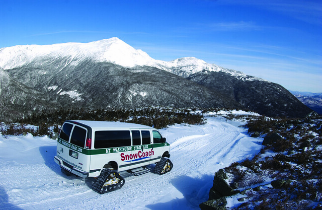 |
| I really want to do this! Snowcoach image taken from http://mtwashingtonautoroad.com/guided-tours/snowcoach/ |
Oilburner videoed the ascent and descent. The ascent just doesn't do it justice. The camera is on the wrong side of the bike, you can't get a feel for how steep everything is. So I'm showing more video of the descent. Please take a clue that you are looking down on the surrounding peaks. That horrid hair pin turn is actually worse going down, not only is the cant of the curve incorrect and steeper in the outside section, you really are looking off into space. There is NO WAY I was "leaning" into any of these curves. Minimum crawl to remain upright was going to have to suffice. The second worst part was the downhill curve on gravel transitioning from inside lane against the mountain, to outside lane next to the drop off. Luckily I didn't encounter any vehicles on this portion as I was in the middle of the road. And I can't honestly say that I would have gotten on my side of the road if anyone was coming. I was considering instituting British or Kiwi road rules and staying on the left if presented with the situation.
During the hair raising moments of ascent I asked Oilburner to just talk to me so I had something to focus on instead of envisioning my fiery arc of death like an Evil Knievel stunt gone wrong. The silence in the helmet was so reassuring because "he couldn't think of anything to say." Ladies and Gentlemen, that is my rock right there...NOT! So on the path down, not remembering any songs longer than one verse, I began warbling "99 Bottles of Beer on the Wall." It too me 51 bottles of beer to get back into treeline, and safety...
At the top, the views were gorgeous. One of the rare days visibility reaches 80+ miles. The temperature was nippy. The wind was steady but not "bull you over" hard. They close the road to motorcycles when it is. Yes, I cried and screamed ascending that hair pin curve. I've only been so scared and frozen one other time in my life when my a$$ was literally hanging over a 30 foot rock ledge and I couldn't find a hand hold. To help you visualize, this is the elevation profile of the points from my GPS track.
 |
| X, Y, Z for track points from my GPS. Represents the slope of the road. |
The rest of the day was blissfully boring eating pizza in our room and going through photos to post on Flickr. I hope you enjoy the video. I realize it is a bit long, but I like it.
Mt Washington Auto Road from Love Of A Motorbike on Vimeo.


 |
| Oilburner says this is they way we are seeing Mt. Washington next time: Glider. |

Subscribe to:
Posts (Atom)
